
Introduction
India’s intricate tapestry of land revenue and property tax has evolved over centuries, underpinned by myriad historical legacies, vast geographical nuances, and rapid urbanization. Reimagining this system calls for an amalgamation of state-of- the-art technology, systemic reforms, and dedication to transparency. By learning from global counterparts, magnifying state-specific triumphs, and embracing modern technological advances, India can herald a new era in land revenue.
Historical context
India’s revenue system, heavily influenced by the British, was a product of its times. The British left behind a legacy of paper maps and records, meticulously maintained. Yet, as cities burgeon and rural landscapes metamorphose, the legacy systems require modern interventions. India’s land revenue system has undergone several changes since the colonial era. The British introduced the zamindari system, which gave zamindars or landlords the authority to collect taxes from the farmers. This system often resulted in unfair and oppressive practices, as the zamindars exploited the farmers and kept most of the revenue for themselves.
The British also conducted land surveys using rudimentary methods, which created inaccurate and outdated maps and records for today’s requirements. After independence, India faced the challenge of reforming the land revenue system and ensuring equitable distribution of land among its citizens.
However, the partition of India and Pakistan created further problems, as millions of people were displaced, and their land rights were disputed. Today, India needs to modernize its land revenue system by using advanced technologies and updating its records to reflect the changing realities of urbanization and rural development.
Global inspirations
Sweden’s Centralization Model: Lantmäteriet: The agency’s success underscores centralization’s potential. Beyond simply offering a unified repository, it has been a model of efficiency, accuracy, and transparency. Integration and Benefits: A singular national database eradicates data discrepancies, propelling both economic growth and real estate development.
Kenya’s Digital Revolution: Shift to Digital: Kenya’s swift transition to a digitized land registry is a testament to the transformative power of technology. Impact: Significant reduction in transfer times and an appreciable decline in bureaucratic corruption and red tape.
U.S.’s Transparent Platforms: Rise of Online Real Estate: Platforms like Zillow have revolutionized property dealings. Offering detailed insights, they’ve made the market more transparent, leading to empowered and informed decision- making by consumers.
Indian innovations and state pioneers
Karnataka’s Bhoomi Initiative: Vision and Execution: The initiative’s ambition to digitize over 20 million land ownership records was no mean feat. By streamlining access, Bhoomi has made land records more accessible. Impact and Successes: Reduced land disputes, increased transparency, and prompted many states to consider similar digital initiatives.
Maharashtra’s Urban Solutions: Digital Property Card Initiative: A testament to the effectiveness of urban-centric solutions. By offering clarity on land titles, these cards serve as a definitive reference point, aiding quick dispute resolution. Pioneering Urban Development: Maharashtra’s approach provides a pathway for other rapidly urbanizing states in India.
Challenges in land mapping in India
India is a unique case wherein undertaking land survey and updating land records was not so easy because of following factors:
- Huge land mass: India is geographically an enormous country wherein undertaking land survey and updating record is a huge, tedious and time and resource intensive It is comparatively easy and convenient to undertake the survey and records updation for a smaller country.
- High density and diversity country: India is diverse with high population density, wherein majority of population is involved in agriculture-based industry wherein any activity involving land is of great importance and hence activities related to change or records updation are usually not
- Small parcel size: The average parcel size in India is small, leading to lot of iterations and features for data collection. Large average parcel size would be any day easy to survey and convenient to update
- Varied Region wise approach: Historically various regions of India have been practicing different methods of land measurement, record keeping and distribution pattern. In contemporary times aligning the entire country with a common approach is a real time
- Limited access to technology: Distribution of technology and resources is varied and skewed wherein rural part of the country is lagging behind as compared to urban areas. This distribution is also varied depending upon region, state, local Governance etc. Therefore, implementing common process across the entire country is complicated and not feasible.
- Education Low literacy level is a barrier and citizens are not receptive for adopting any new activity related to land which is their prime base of living for major part of population.
- Poverty and low income A major part of the population is in low income strata and experience poverty, therefore any prospective change related to their source of income wrt land is usually not acceptance and more likely to generate
Considering the above challenges, it was imperative on the part of Centre Government to drive this initiative. Also, this was important for establishing a common understanding and approach. However, for implementing it was prudent to involve respective states, local bodies and private sector organizations.
Technological disruptions in land record mapping

Source: https://www.ghar.tv/blog/pics/813.jpg?1696756109
Land records are essential for ensuring the security of property rights, facilitating land transactions, and supporting urban and rural development. However, in many parts of India, land records are outdated, inaccurate, or incomplete. This poses challenges for land administration, governance, and planning. To address these issues, technological innovations such as Geographic Information Systems (GIS) and drones have emerged as powerful tools for land record mapping and modernisation.
Precision with Geographical Information System
GIS is a system that captures, stores, analyses, and displays geospatial data. It enables the integration of various types of data, such as satellite imagery, aerial photographs, topographic maps, cadastral surveys, and socio-economic indicators. By using GIS, land record mapping can achieve a high level of precision, accuracy, and reliability. GIS can also help in identifying and resolving land disputes, detecting encroachments, and updating land records.
GIS in Action: A detailed look into how GIS systems, with their multi-faceted capabilities, have brought about game- changing precision to land mapping. One of the examples of how GIS has been used for land record mapping and modernisation in India is the Bhoomi project in Karnataka. The project aimed to computerise land records and provide online access to landowners. It involved digitising over 20 million records of rights, tenancy, and crops (RTC) for more than 6.7 million land parcels.
The project also used GIS to create spatial databases of land parcels, village boundaries, roads, water bodies, and other features. The project improved the transparency, efficiency, and accountability of land administration in the state. Urban Planning: Leveraging GIS, urban planners can make informed decisions on city expansion, infrastructure development, and more.
Another example of how GIS has been used for land record mapping and modernisation in India is the Delhi Geospatial Delhi Limited (GSDL) project. The project aimed to create a comprehensive geospatial database of the national capital territory of Delhi. It involved capturing high-resolution satellite imagery, conducting ground surveys, and integrating various layers of data such as land use, property tax, utilities, transport, environment, and heritage. The project enabled urban planners to visualise the current and future scenarios of the city and plan accordingly.
Aerial insights with aerial flying, High Resolution Satellite Imagery (HRSI) and drones
Imageries from Aerial flying are obtained by flying the specially designed aircrafts with high resolution sensors at low altitudes. For this, permissions are obtained as per the Government guidelines which is usually finance intensive, lengthy and cumbersome process. The output thus obtained is of high resolution with good quality and the process of obtaining images is fast.

High resolution satellite imagery
With the technological advancement, nowadays satellites imageries are available with various resolutions and sensors which may be used as inputs for updating land records.
High resolution satellite imageries are readily available and in case these are not available for target area then target based fresh tasking may be undertaken. These satellites are of both Indian and foreign origin and ownership may be Government of private. At times Aerial Photography Aerial Data after Security Vetting (Masking of restricted areas)
Drones
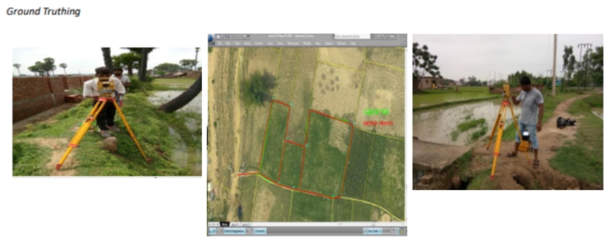
Drones are unmanned aerial vehicles that can fly autonomously or remotely controlled. They can carry cameras or sensors that capture images or data from the air. They offer several advantages over traditional methods of land surveying, such as speed, cost-effectiveness, safety, and flexibility. Drones can also access remote or difficult terrains that might otherwise be inaccessible or hazardous. The Drone Revolution: The advent of drones has fundamentally transformed land surveying. With high-resolution imagery, drones offer a bird’s eye view, capturing nuances that traditional methods might miss.
One of the examples of how drones have been used for land record mapping and modernisation in India is the Maharashtra Land Records Modernisation Programme (MLRMP). The programme aimed to update and digitise land records in the state using drones. It involved flying drones over more than 40,000 villages and capturing orthophotos (geometrically corrected aerial photographs) of the land parcels. The programme also used artificial intelligence (AI) to automate the process of extracting cadastral information from the orthophotos. The programme enhanced the quality and accuracy of land records in the state.
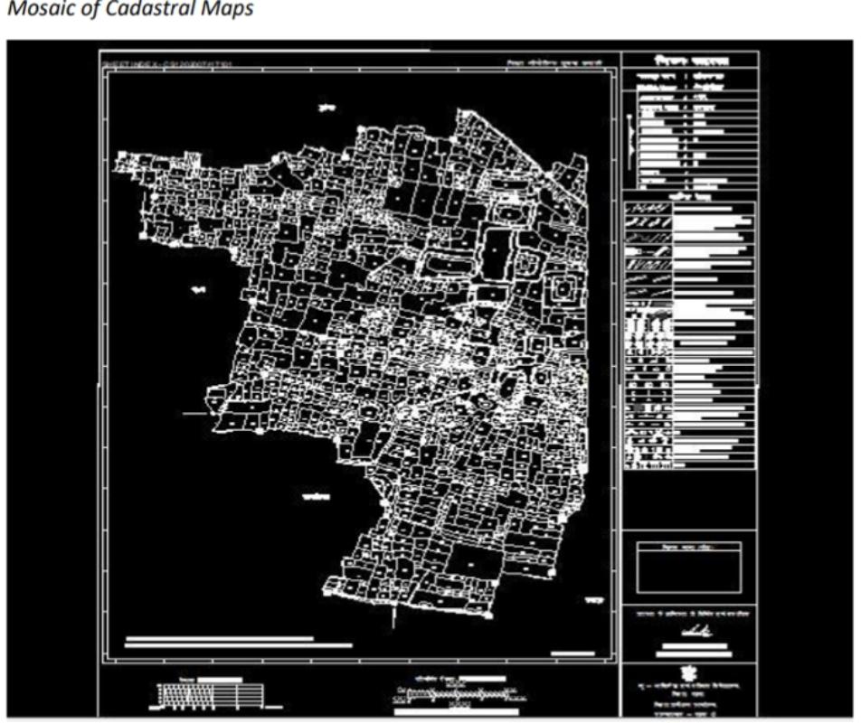
Mosaic of cadastral maps unlocking remote terrains
Often, terrains that are challenging or impossible to access traditionally can easily be surveyed with drones. Another example of how drones have been used for land record mapping and modernisation in India is the Survey of India (SoI) project in Uttarakhand. The project aimed to map the hilly and forested areas of the state using drones. It involved flying drones over more than 6,000 square kilometres and capturing high-resolution images of the terrain. The project also used photogrammetry (the science of making measurements from photographs) to create digital elevation models (DEMs) and contour maps of the terrain. The project facilitated the planning and development of infrastructure, tourism, agriculture, and disaster management in the state.
LiDAR (Laser imaging, Detection, and Ranging)and 3D Mapping
An exploration of how advanced drones, when combined with LiDAR technology, create detailed three-dimensional representations. This is paramount in urban planning, environmental studies, and infrastructure development. LiDAR is a remote sensing technology that uses laser pulses to measure distances. It can penetrate vegetation and clouds and create accurate 3D models of the surface. When mounted on drones, LiDAR can capture high-density point clouds (collections of points that represent a 3D shape) of large areas in a short time.
One of the examples of how drones and LiDAR have been used for land record mapping and modernisation in India is the National Hydrology Project (NHP). The project aimed to improve water resources management in the country using drones and LiDAR. It involved flying drones over more than 100 river basins and capturing LiDAR data of the terrain. The project also used hydrological modelling to estimate the water availability, demand, and quality in the basins. The project supported the decision-making and policymaking for water resources management in the country.
Enhancing revenue records through data integration Incorporating utility and urban data
- Multi-layered Data Approach: Combining utility data provides a holistic perspective on land Understanding a
property’s water, electricity, and sewage connections can significantly affect its valuation.
- Role in Urban Metrics: By integrating data related to amenities, connectivity, and infrastructural developments, revenue record management becomes more
Dynamic data updates
- Evolving Landscapes: Regularly updating records ensures they mirror the dynamic shifts in urban and rural
- Real-time Accuracy: A continuous data update approach aids in precise revenue calculations, reflecting the true value of
Challenges faced in land record updation in India from a real-life case study
Delays in obtaining input imageries: Obtaining aerial flying permission is time consuming and problematic process which often results in delaying these projects.
Technological constraints among stakeholders Government being the important stakeholder is short of technically compatible and capable resources. In most of the instances they are still evaluating technologies and establishing the processes.
Lack of storage and data handling capabilities Land records updation projects involve data handling of huge data size and require technical capabilities including large data centres. At most of the places, there are limited data handling capabilities and storage facilities thus constraining successful implementation of such projects.
Feasibility Aerial photography in bordering areas India is surrounded by certain countries with which we have security sensitive relationships and obtaining aerial/ drone flying permissions are literally not possible.
Slow progress Government is one of the main stakeholders in land related projects. Considering the process transition, financial availability and disbursement and other priorities, land related projects are unlikely to be driven with high turnaround time.
Recommendations and the path ahead
- Centralized Database: Building a Unified Repository: Delving into the intricate steps and benefits of creating a centralized database that ensures data uniformity and ease of access.
- Implementation Challenges: Discussing the potential roadblocks and strategies to overcome them.
- Transparent Online Platforms: The Digital Future: Detailing how transparent online platforms can redefine India’s real estate landscape, making it more user-friendly and reducing discrepancies.
- Regular Training Modules: Need for Continuous Learning: Emphasizing the significance of continuous training to stay updated with global best practices.
- Community Engagement: Ground-level Reality: How community participation can ensure that land records reflect actual ground realities, leading to more accurate and fair revenue generation.
- Overcoming Challenges and Prospects: Privacy Concerns: Navigating the Digital Age: As land records go digital, data security and privacy emerge as primary concerns. How can India ensure stringent data protection while promoting transparency?
- Skill Development and Capacity Building: Training the Workforce: The importance of equipping the workforce with the skills necessary to navigate the evolving technological landscape.
Conclusion
India stands at a pivotal juncture, with the potential to redefine its land revenue mapping and property tax collection system. The challenges, while substantial, are surmountable with a dedicated, holistic approach. The journey might be long and arduous, but the destination promises a transparent, efficient, and modern revenue system that could serve as a beacon for countries worldwide.


