Introduction
The Union Minister of Environment, Forest and Climate Change, Mr. Bhupinder Singh released the 18th biennial report on forests called India’s State of Forests – 2023 (ISFR-2023) in Dehradun on 21st December 2024. The Union Minister expressed his happiness for increasing 1445 sq km forest and tree cover compared to 2021. The report claims that India’s forest and tree cover has now increased to 25.17% of the total geographical area of the country. Out of this the tree cover, which is manually surveyed patches of tree cover outside of the recorded forest and “green wash” accounts for 3.41%.
 Source: ISFR, 2023
 Source: ISFR, 2023
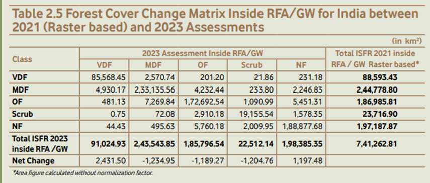
The report reveals that the total forest cover inside the FRA/GW has increased from 520358.04 sq. km in 2021 to 5,20,365.32 sq km in 2023. In the category of Very Dense Forest (VDF) which comprises forest with more than 70% of canopy density increased from 88,593.43 sq km in 2021 to 91,024.93 sq km in 2023. In these two years, India added 2,431.5 sq km more to the very dense forest.
Forest cover outside recorded forest area (RFA) contributes significantly in the total forest cover of India. According to the latest ISFR report, nearly one third (27%) of the total forest cover is outside the recorded forests. These forest patches include forest in land not categorized and forest in government documents.
The report reveals that the forest cover outside the recorded forest has increased from 1,94,828.16 sq.km. in 2021 to 1,94,977.29 sq km in 2023.
In this category of the forest cover the very dense and moderately dense forest has observed decline in these two years. They degraded to subordinate canopy cover categories. The open forest in this type of forest cover has increased by 629.48 sq km in these two years.
Low forests cover within recorded forests
The Forest Survey of India (FSI) defines forest cover as all lands, more than or equal to one hectare in area, with a tree canopy of more than or equal to 10%, irrespective of ownership and legal status; and includes orchards, bamboo, and palm.
This definition clarifies that the legally recognized forest is different from forest cover presented in successive ISFRs produced by the Forest Survey of India. It defines the Recorded Forest Area (RFA) as land recorded as forest in government records.
The recorded forest area largely consists of the ‘Reserve ‘Reserved Forests’ (RF) and the ‘Protected Forests’ (PF), constituted under the provisions of the Indian Forest Act, 1927.
Besides the RFs and PFs, the recorded forest area may also include all such areas which have been recorded as ‘Unclassed Forests’, ‘Village Forests’, or by any other nomenclature of such description, and all such areas which have been recorded as forest in the revenue records, or have been constituted so under any State Act or local law.
Forest Cover inside Recorded Forest Area
| Forest Category (A) | Total Forest Cover (Area in sq km) (B) | Forest Cover within Recorded Forest Area (C) | Difference |
|---|---|---|---|
| Very Dense Forest | 1,02,502.2 | 91,024.93 | 11,477.27 |
| Moderately Dense Forest | 3,07,673.28 | 2,43,543.85 | 64,129.43 |
| Open Forest | 3,05,167.13 | 1,85,796.54 | 119,370.59 |
| Total | 7,15,342.61 | 5,20,365.32 | 194,977.29 |
Source: ISFR, 2023
The latest ISFR report of 2023 reports that the total recorded forest area (RFA) in India is 7,75,377 sq km, which accounts for 23.59% of the total geographical area of the country. Out of this 4,43,253 is reserve forests, 2,12,859 is protected forest and 1,19,265 is unclassed forest across the country.
Further the report suggests that out of 7.75 lakh sq.km of recorded forest, only 5.20 lakh sq km forest land has actual forest cover of varying canopy density. As much as 2,55,012 sq km of forest land has no forest cover. This forest land with any forest covers constitutes around 33.89% of the total forest land. In other words, more than one third of forest land of India has no forest cover despite schemes like CAMPA and Green India Mission.
Forest without forest cover uneven distribution across the country. There are seven states namely Punjab, Himachal Pradesh, Sikkim, Rajasthan, Uttarakhand, Haryana and Gujarat, which do not have any forest cover on its more than 50% of recorded forests.
Forest Cover Inside Recorded Forest Area (Major States)
| State/UT | Geographical Area (sq km) | Recorded Forest Area (RFA) | Total Forest Cover Inside RFA/GW (sq km) | % RFA without Forest Cover |
|---|---|---|---|---|
| Punjab | 50,362 | 3,084 | 775.76 | 74.85 |
| Himachal | 55,673 | 37,033 | 10,706.97 | 71.09 |
| Sikkim | 7,096 | 5,841 | 2,060.63 | 64.72 |
| Rajasthan | 3,42,239 | 32,737 | 12,706.14 | 61.19 |
| Uttarakhand | 53,483 | 38,000 | 16,899.28 | 55.53 |
| Haryana | 44,212 | 1,559 | 728.93 | 53.24 |
| Gujarat | 1,96,244 | 19,653 | 9,389.87 | 52.22 |
| Jharkhand | 79,716 | 23,605 | 12,502.53 | 47.03 |
| Uttar Pradesh | 2,40,928 | 16,582 | 9,338.76 | 43.68 |
| Odisha | 1,55,707 | 58,136 | 33,040.47 | 43.17 |
| Maharashtra | 3,07,713 | 61,935 | 36,110.93 | 41.70 |
| Karnataka | 1,91,791 | 38,284 | 23,013.90 | 39.89 |
| Andhra Pradesh | 1,62,923 | 37,258 | 23,867.76 | 35.94 |
| West Bengal | 88,752 | 11,879 | 7,688.56 | 35.28 |
| Jammu & Kashmir | 2,22,236 | 20,230 | 13,112.03 | 35.19 |
| Bihar | 94,163 | 7,442 | 4,865.74 | 34.62 |
Source: ISFR, 2023
The compensatory afforestation program (CAMPA) has been in operation in the country for more than two decades with the sole purpose to plant trees with dedicated funds, which is ever increasing. Moreover, the government of India has also initiated the Green Mission as an approach to address issues of climate change. This program also focuses on plantation. Yet, a huge amount of forest land remains without forest cover in the country.
In some states the forest land without forest cover is also possible because of permanent snow-covered regions in Himalaya and desert in Rajasthan. Yet, there are many states in the list which do not have such extreme conditions.
Tree cover as proxy of forests
The ISFR has been recording tree cover of India from 2001. As of the latest ISFR the total tree cover of India is about 1,12,014.34 sq km, which accounts for 3.41% of the total geographical area of the country. The tree cover area reported by the ISFR constitutes more than 13% of the total forest/tree cover of India.
The ISFR defines the tree cover as, “Tree cover comprises all tree patches outside the forest area, which are less than one hectare in extent including all the scattered trees found in the rural and urban settings, and not captured under the forest cover assessment.” While the forest cover both inside and outside the recorded forest area is done using satellite images, the tree cover is measured using offline forest inventory.
The maximum tree cover has been found in the State of Maharashtra (14,524.88 km2 ) followed by Rajasthan (10,841.12 km2 ) and Uttar Pradesh (8,950.92 km2 ). The maximum positive change as compared to ISFR 2021 has been observed in Chhattisgarh (702.75 km2 ) followed by Rajasthan (478.26 km2 ) and Uttar Pradesh (440.76 km2 ). In general, twenty-one States and UTs have shown an increasing trend in tree cover, which indicates that agroforestry, is being promoted in these States.
Successive ISFRs observed uneven progress of the tree cover of India since 2001. The latest ISFR reports that the tree cover has reached 3.41% of the total geographical area which was 3.04% two decades ago in 2003. It had fallen to 2.76 of the total geographical area in 2011. In comparison to ISRF-2021, the tree cover has increased from 2.91% in 2021 to 3.41% in 2023. In these two years the tree cover has sharply increased by 0.5%.
Experts have expressed their apprehension about tree cover which is now a significant portion of India’s inventory of forest cover. Experts have argued that tree cover includes trees and spaces such as fruit orchards, rubber plantation and sugarcane fields.
Major states with Tree Cover
| State/UT | Tree Cover 2023 (sq km) |
|---|---|
| Maharashtra | 14,524.88 |
| Rajasthan | 10,841.12 |
| Uttar Pradesh | 8,950.92 |
| Madhya Pradesh | 8,650.14 |
| Karnataka | 7,779.15 |
| Gujarat | 6,632.29 |
| Chhattisgarh | 6,538.70 |
| Odisha | 6,163.45 |
| Tamil Nadu | 5,370.72 |
| Andhra Pradesh | 5,340.02 |
| Jammu & Kashmir | 3,666.97 |
| Jharkhand | 3,637.55 |
| Telangana | 3,517.66 |
| West Bengal | 2,938.12 |
Source: ISFR, 2023
Degradation of Natural Dense Forests
The forest survey of India categorizes forest into three categories namely Very Dense Forests (VDF), Moderately Dense Forests (MDF) and Open Forests (OF). The very dense forest have canopy density more than 70% and moderately dense forest have canopy density between 40% to 70%. The open forest is a forest which has a canopy density of more than 10% but below 40%. Since 2001 the Survey of India has been recording data of forest under these three categories in successive India’s State of Forest Reports (ISFRs).
Various factors, both natural and anthropogenic, contribute to inter-category changes of these forests. The loss of canopy density can degrade forests and addition in canopy density can upgrade forests.
The following table compiled by the Indian express shows that various changes in the last two years substantially changed the status of a large forest land. In summary, we lost 9,388 sq km of forest land during 2021 and 2023. However, we also manage to regenerate 10,104 sq km of forest land.
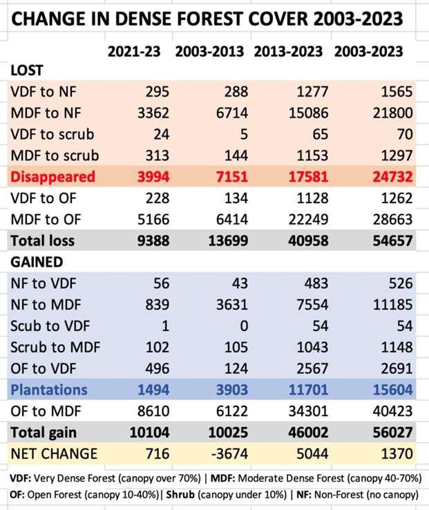 Source:
https://indianexpress.com/article/explained/growth-of-india-green-cover-not-all-good-news-9740450/
Further, comparing quality of Indian forest in last two decades from 2003 to 2023, we see that total 54,657 sq km forest land wad degraded from higher canopy density to lower canopy density. Moreover 56,027 sq km of forest land was also regenerated by improving canopy density. Of this plantation was carried out on 15,604 sq km and 11,185 sq km non forest land was converted into forest cover.
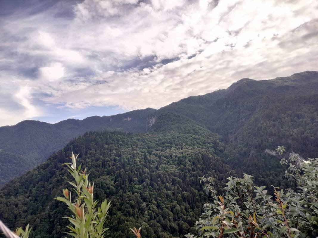
Forests in Himalayan states
The Indian Himalayan region is divided into two broad segments: eastern and western Indian Himalaya. The eastern Himalaya comprises north eastern states namely Manipur, Mizoram, Meghalaya, Nagaland, Arunachal Pradesh and Sikkim. Western Indian Himalayas consist of the states of Himachal Pradesh, Uttarakhand and UTs of Jammu & Kashmir and Ladakh. The entire Indian Himalayan region is highly fragile and sensitive to both natural calamities and anthropogenic activities. Earthquakes, GLOFs, Floods, Forest Fires are major devastating Himalayan disasters which get accelerated due to the high rate of anthropogenic activities in the region.
Forests in the Himalayan region plays an important role in preventing devastating impacts of disasters and improving regional climate change resilience. In the last two decades the total forest cover of the Indian Himalayan region has increased from 1.94 lakh sq km in 2001 to 1.96 lakh sq km in 2023. It accounts for an absolute increase of 2,399.69 sq km of forest cover in the region. However the forest cover in the eastern Himalayan region has observed an absolute decrease of 1,582 sq km during the period.
Forest Cover in Indian Himalayan States
| State/UT | 2001 (Area in sq km) | 2023 (Area in sq km) | ||||
| Dense Forest | Open Forests | Total Forest Cover | Dense Forest | Open Forests | Total Forest Cover | |
| Ladakh | NA | NA | NA | 511 | 1,775 | 2,286 |
| Himachal Pradesh | 10,429 | 3,931 | 14,360 | 10,398 | 5,182 | 15,580 |
| Jammu & Kashmir | 11,848 | 9,389 | 21,237 | 12,216 | 9,131 | 21,346 |
| Uttarakhand | 19,023 | 4,915 | 23,938 | 17,784 | 6,520 | 24,304 |
| Sub Total (West Himalayas) | 41,300 | 18,235 | 59,535 | 40,909 | 22,608 | 63,516 |
| Manipur | 5,710 | 11,216 | 16,926 | 7,122 | 9,464 | 16,585 |
| Meghalaya | 5,681 | 9,903 | 15,584 | 9,619 | 7,348 | 16,967 |
| Mizoram | 8,936 | 8,558 | 17,494 | 8,897 | 9,093 | 17,990 |
| Nagaland | 5,393 | 7,952 | 13,345 | 5,718 | 6,504 | 12,222 |
| Sikkim | 2,391 | 802 | 3,193 | 2,659 | 699 | 3,358 |
| Arunachal Pradesh | 53,932 | 14,113 | 68,045 | 50,600 | 15,281 | 65,883 |
| Sub Total (East Himalayas) | 82,043 | 52544 | 134587 | 84,615 | 48390 | 133005 |
| Grand Total (Himalayas) | 1,23,343 | 70,779 | 1,94,122 | 125,524 | 70,998 | 1,96,522 |
Source: ISFR, 2001 and ISFR, 2023
While the western Himalayan region has observed increase in the total forest cover between 2001 and 2023 its quality of forest cover has deteriorated. The dense forest (comprising of very dense and moderately dense forests) in the western Himalayan region has decreased from 41,300 sq km in 2001 to 40,908.79 sq km in 2023. Uttarakhand and Himachal Pradesh observed degradation of its dense forests. The degradation of dense forests in Uttarakhand is significantly high. Its dense forests have decreased from 19,023 sq km in 2001 to 17,784 sq km in 2023. In the eastern Himalayan region only Mizoram and Arunachal Pradesh observed degradation of its dense forests between 2001 and 2023.
Conclusion
Biennial publication of India’s State of Forest Report (ISFR) of Forest Survey of India is an important document for researchers, conservationists and policy makers. The FSI has improved its data collection and methods significantly to source more accurate information. Moreover, its scope has also widened in last three decades to meet contemporary environmental and climate challenges.
The 18th India’s State of Forest Report released on 21st December 2024 in gives many positive messages including significant increase in the total forest and tree cover of India. The report claims that for the first time, India’s tree and forest cover has crossed 25% of India’s total geographical area. While there are many things to applaud and celebrate in this report, we need to also be informed about our shortcomings and areas for improvement. In this article we have highlighted four areas where improvements are required. These areas includes focusing on one third of recorded forest which has no forest cover, heavy dependence on tree cover to improve our green cover, degradation of natural dense forests and rapid degradation of Himalayan forests.