Background
The Bodoland Territorial Region consists of four districts of Assam namely Kokrajhar, Chirang, Baksa and Udalguri is known for its unique social, economic, ethnic, linguistic and cultural identity. To protect the interest of local residents and fulfil their aspirations the Bodoland Territorial Council was constituted under the sixth schedule of the constitution in 2003. The Bodoland Territorial Council (BTC) functions as an autonomous system of governance on subjects transferred to the council by the state government. The region comprises more than three million people and is highly dependent on agriculture. The main crop being cultivated in the region is paddy. Being agriculture as the main occupation, the community is heavily dependent on natural resources such as river, streams, ponds, hills, forest and highly diverse flora and fauna. The one third area of the region is covered with forest that supports subsistence economy.
Other than the Bodo tribe the region also inhabits people from Assamese, Bengalis, Koch-Rajbongshis, Rabhas, Garos , Adivasis, Muslims and Nepali communities. Out of 2890 revenue villages, 2272 villages are predominantly inhabited by people from Bodo tribe. These tribal villages have a rich tradition of managing their common property resources (commons) such as forest, land and water. Tribal communities in the entire Baksa district have formed Village Committees (VC) consisting of entire households in the village/hamlets for regulating and up-keeping of village common properties. These village committees are responsible for the management, regeneration, and exploitation and sharing of benefits from common property resources. The VCs play a vital role in resolving internal village conflicts and also keeping robust relations with nearby villages at the same time deal with local administration for bringing resources within the village. Village councils are not formal institutions but they play an important role at the local level.
Villages in the Bodoland Territorial Region also have a tradition of digging canals for the purpose of irrigation. These canals are locally called ‘Dong’ and most of these dongs originate from a river or water stream. These dongs in many places are used effectively for Kharif crops, especially paddy, as the water flow is high at that time. In the winter season selected people use dongs for cultivation of vegetables and mustard crops. Considering the usefulness of these dongs, villagers have formed Dong Committees for effective management of the Dongs e.g. cleaning, constructing canals, repairing and sharing / distribution of water in each village, enforcing discipline and conflict resolutions within the village as well as inter village. Some of these dong committees are more than 100 years old. Unlike the village committees (VC), Dong Committees are formally registered as society under the Society Registration Act, 1860.
Like in many other parts of the country, the people of Bodoland Territorial Region are highly dependent on common property resources such as forest, water, hills and land for their livelihood. These resources contribute significantly in the subsistence economy of the region. One of the common resources that have been used extensively by villages in this region is water. The river systems and streams were used for drawing water to agricultural fields by the local populations across the villages, thus Dong (Canal) based systems came into existence in district of Baksa and its adjoining districts of Chirang (towards west of Baksa) and Udalguri (towards east of Baksa). The Dongs are the lifeline for agriculture in villages of Baksa district. For the management and upkeep of these crucial resources, these villages have Village Committees and Dong Committees in place. These two community based institutions are part of their tradition and lifestyle. While it is common to have these two committees in tribal villages in this area, their work and priorities may differ from village to village. Since there is no common rule for the functioning of these committees, the function of these two institutions depends on the requirements of villagers and understanding/leadership of members of their management committees.
This paper attempts to describe functions and priorities of Dong Committee in the Ambrabati village and Village Committee in the Pub Hazira village in the Baksa district of the Bodoland Territorial Region. Both of these are typical tribal villages of the region with populations of more than one thousand each. The village committee of Pub Hazira manages three ponds and about 2 hectare agricultural land. Every year the committee leases them out to individuals and earns cash, which is then used for several purposes. On the other hand Dong Committee of the Ambrabati village is a complex set-up formed by seven different sub-committees. The role of committee is to manage the water of the canal originating from Gurakhowa spring in village Manikpur. It charges a certain amount from the water users, which is then used for the upkeep of the canal. While the Village committee of Pub Hazira has focused on earning hard cash for common use, the dong committee of Ambrabati attempts to ensure better agricultural production of each household by managing dong water.
This paper is part of a study on ‘Regeneration of common property resources as a basis for revival of the rural economy in the time of COVID’, commissioned by the Rajiv Gandhi Institute for Contemporary Studies. The study adopted qualitative research methods such as focus group discussions, interviews and case studies to collect first hand information. The field work was carried out by the Kabil Foundation and SANJOG in Assam. In this paper we will discuss these two models of CPR management and challenges faced by them.
The Hazira Village
Hazira is inhabited by Bodo populations situated 13 Km from the district head quarter Baksa in Assam. It is a typical Bodo village of 228 families comprising a population of 1067. Almost the entire village is dependent on agriculture and livestock for their livelihood. However the average land holding is as low as 0.35 hectare. Overwhelmingly 195 families are either marginal or small farmers. Moreover, 30 families in the village are farm labourers. The livestock is another means for livelihood for almost all villagers. They have a tradition of rearing cows, goats and pigs. In our field observation and focus group discussion, we observed that on an average each family has 4-5 livestock. The cows and piggery can be found in every house however, only around half of the families in the village have goats. A brief overview of the demographic and livelihood profile of the village is given in the following matrix.
Demographic and Livelihood Profile of Hazira
| Total Population of the village | 1076 |
| Total Number of Households | 228 |
| Households dependent on combination of agriculture and livestock | 225 |
| Number of small and marginal farming households | 195 |
| Number of Farm Labourer Households | 30 |
| Number of households dependent on occupation other than farming and livestock but draws benefit from CPR | 3 |
| Number of households whose member (s) seasonally migrates for livelihood in the cities | 70 |
| Number of households whose member (s) migrated permanently for earning livelihood in the cities | 0 |
| Number of worker migrated back to the village after lockdown to contain COVID-19 | 18 |
The combination of agriculture and livestock is the main source of livelihood for the villagers in Hazira. However, the subsistence economy based on these two occupations is not enough to meet requirements of local villagers. To meet their additional requirements, many villagers migrate to nearby cities or cities outside Assam as seasonal labourers. In the Hazira village members of 70 out of 228 households migrate seasonally in search of the job. In March 2020, after the announcement of the nationwide lockdown to contain the spread of COVID-19, 18 workers went back to their village. Compared to the size of the village, the outmigration for livelihood is very high. The data above shows that both the average land holding and possession of livestock is very low in the village, therefore it creates situations for distress migration from the village.
Commons and Village Committee of Hazira
The common property resources (commons) are crucial for the sustenance of rural occupations namely agriculture and livestock. There are examples where villagers invented new occupations using their common property resources. Like in other parts of the country, the Hazira village also has access to common property resources in and around the village. Some of these resources are owned by the village committee however, in some cases, villagers are de-facto users of resources owned by the government.
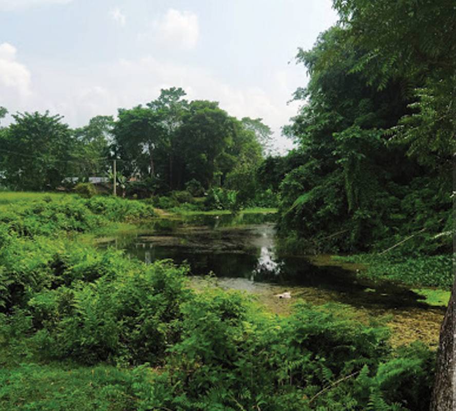
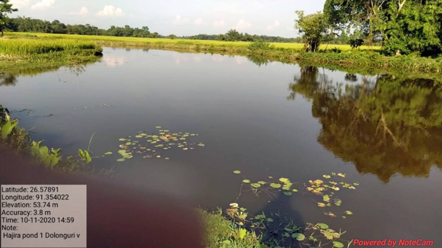
The village has two main common resources- three community ponds and common paddy fields. Both of these resources are directly linked to the livelihood. While the area where three ponds are located belongs to the state government, common paddy fields are owned by the village committee of Hazira. Brief detail of the three ponds is as follows:
| Names of the community ponds | Area covered |
| Dolongbari | 8 bigha (1.12 Ha)
Average depth : 4.5-5 Feet (say 1.5 meter) Volume of water : 16,800 cubic meter |
| Singimari | 3 bigha (0.4 Ha)
Average depth : 6-8 feet (say, 2 meter) Volume of water: 8000 cubic meter |
| Chetna | 3 bigha (0.4 Ha)
Average depth : 6-8 feet Volume of water : 8000 cubic meter |
River Chetna emerging from Bhutan hill changed its course from Hazira to nearby village due to floods in the year 1998. Chetna flows towards west of the village to merge in river Tihu which eventually merges in mighty Brahmaputra towards South of the village. Change of course of Chetna left behind low lying areas transformed into patches of wetland. The Village committee decided to approach the government through the local Block Office to seek support for construction of embankments in the wetland areas to renovate it into community managed fishery ponds. The Block Office obliged with a grant of Rs.30,000/- as labour cost to the entire village for construction of embankments surrounding the ponds. Around 150 nos. of households from the village engaged by giving four days of labour for construction of embankments to transform the entire patch of wetland into a community pond. Since then community manages the ponds and income generated is utilised for reinvestments in the ponds like purchase of fish seeds & fingerlings, cleaning, donations for festivities like Puja and Bihu and also if left over loaning farmers during the Sali (June /July to Nov/ Dec) season paddy crops.
The ponds are contracted to the highest individual bidder within the village in annual meetings of the VC. The event occurs annually and the margin left from the bidding is taken as profit for the entire village. The bidding process is done as villagers are not able to look after the pond collectively. Perhaps greater engagement of some development agency in the village can increase margins of profit for the VC manifold.
The village committee also owns 2 hectare of paddy field in the villages. This area is given to interested households of the village for paddy cultivation. The leasing out of land is done on an annual basis using a lottery system. The contracted village households give 1500 Kgs of paddy per Ha to the Village Committee. That is 3000 Kgs for 2 Ha of land where average production stands at 7200 Kgs . The same is sold during the Bihu for arranging events in the village. If money is saved it is lent to households within the village with interest of @5% per annum.
The affairs of the village are managed by Mazusupa Mini Swarang Village Committee. The village has common properties which is looked after by the villagers and income generated is utilised to manage common resources within the village and also represent the village in different outside forums and meetings. The Village Committee comprises all Village households, led by the President/Secretary chosen by village households in Annual General Meeting every year. The President/Secretary is chosen during the AGM with consensus of all village households through a voice vote by saying Yes/No. But there are elaborate discussions by village households before coming down to names. Once names are finalised through the vote the, same is noted down in the minute’s book. Before finalising the names attributes like writing abilities and common acceptance of the persons elected in the community is assessed. The village committee is not a legally registered body, but it has a system of keeping records and documenting proceedings and events. The committee’s records are kept in the form of minutes book and cash book. Any conflict that arises is solved amicably by villagers through meetings.
Based on focus group discussions organized in the village, it was found that in the last financial year the village committee earned Rs. 70,000 from three fish ponds and 1,05,000 from paddy fields by contracting them. The committee further invested Rs. 40,000 in these three ponds by purchasing fish seeds and fingerlings. Apart from this, a hefty amount of Rs. 60,000 from the total earning of the committee was used for various festivals and rituals in the village. It was also observed that mostly poor families are interested in contracting paddy field. However, the relatively richer family gets the contract of a fish pond every year.
Observations and Suggestions
Ponds are often infested by aquatic weeds e.g. water hyacinth etc. and need regular maintenance to keep the required hygiene condition of the water body for good growth of fishes. Feeding and protection from diseases and pests are also very important practices. As of now such practices are not being followed in these ponds.
The villagers do not follow improved fish rearing practices. Otherwise, these ponds with a total volume of water about 32,000 (thirty two thousand) cubic meters can produce a minimum 8,000 kilogram of fishes (assumption made is 0.25 kg of fish/ cubic meter of water per annum. (This could be as high as 1 kilogram / cubic meter of water with good scientific management practices). The market price of common carp is minimum Rs.100 / kilogram. Thus, the value of 8000 kilogram of fish would be Rs. 8, 00, 000. This is much higher than what they are getting now (Rs. 70,000). Integration of duck rearing along with fishery could generate much more income. The estimate made above is basically to indicate the potential of such resources.
The Ambrabati Village
The Ambrabati village is just three kilometres from Baksa district headquarter in Assam. It is predominantly a Bodo village, comprising 1954 Bodo people and 743 people from other backward communities (OBCs). Ambrabati village is one amongst many villages settled about more than 100 years ago on the Indo-Bhutan border across Assam. Much of the settlements occurred during the British Raj who brought labourers from Aadivasi belts of Jharkhand, Madhya Pradesh, Chhattisgarh and other such areas to work in tea gardens. The local tribal populations (mostly Bodo and Rabha tribes) also settled in the area clearing forests and establishing new villages. A brief overview of the demographic and livelihood profile of the village is given in the following matrix.
Demographic and Livelihood Profile of Ambrabati
| Total Population of the village | 2697 |
| Total Number of Households | 830 |
| Households dependent on combination of agriculture and livestock | 830 |
| Number of Large farming households | 2 |
| Number of small and marginal farming households | 756 |
| Number of Farm Labourer Households | 72 |
| Number of households dependent on occupation other than farming and livestock but draws benefit from CPR | 0 |
| Number of households whose member (s) seasonally migrates for livelihood in the cities | 45 |
| Number of households whose member (s) migrated permanently for earning livelihood in the cities | 0 |
| Number of worker migrated back to the village after lockdown to contain COVID-19 | 12 |
Villagers of Ambrabati are dependent on a number of occupations for their livelihood. Main occupations are agriculture, livestock and daily wage labourers. A large proportion of households in the village are small and marginal farmers with land holding less than 2 hectare. As many as 72 families are farm and other daily wage labourers. However, a daily wage labourer also comprises a household with some land holding. Other than the agriculture and wage labourers, livestock is another major source of income in the village. Rearing cows, pigs and goats is common in the village. The focus group discussions with villagers revealed that on average a household keeps one cow, four goats and two pigs.
Despite being very close to the district headquarters; the villagers of Ambrabati migrate to other cities and states for employment. Members of 45 households in the village migrate seasonally to earn livelihood. Many of these migrant workers find jobs in cities like Bangalore. Due to the nationwide lockdown in March 2020, only 12 workers could manage to come back home. All these workers are willing to stay back in the village, if employment is available.
Commons and the Dong Committee of Ambrabati:
The Ambrabati village has been managing three main common property resources for years. These include a community pond with an area of 1.1 hectare, an irrigation canal (6 km) and community paddy field (0.53 hectare). The community paddy field and community pond are managed by the village committee of Ambrabati. The constitution and function of the village committee is similar to the village committee of Hazira, which is described in the above section in this document. The unique thing about this village is that the village committee purchased the land for the construction of a fish pond. The fish harvested from the pond is sold to traders on a yearly basis. The earned money is used for reinvesting for buying fish seeds and the rest of the money is kept for maintenance of village infrastructure like temples, meeting hall and others such as sometimes village roads. The income from this pond is not high but better management and systematic fishing can yield better return to the village. One part of the community land owned by the village committee is used as a playground for the school. Another part of the land (around 0.66 acre) is used for paddy cultivation by the village committee with an average production of 1000kgs of paddy in a year. The harvested paddy is sold and returns are utilised for investing in events like Puja and festivities like Bihu.
The management of irrigation canal by the dong committee of the Ambrabati village is distinct from the case of Hazira. Irrigation canals as mentioned in the beginning are very crucial for the subsistence economy of the area and there is a rich tradition of constructing and managing these canals. Locally canals are called Dong. The Gaurkhowa Dong of about 6 km serves farmers of the Ambrabati village. Nearly 285 out of 672 hectare of agriculture land of the village gets water from this dong in the kharif season. In the rabi season only 4 hectare land gets water for cultivation of mustard seeds. In total 427 families benefit from this canal.
The Gurakhowa dong emerges from Gurakhowa spring (jhara) in village Manikpur under Baska Development Block of Baksa district. The Gurakhowa canal emerges from spring (a patch of 5 feet wide and 40 feet long wet land from where water oozes out) unlike other canals in Baksa district which originates from hills of Bhutan barring few other canals. Villagers of Ambrabati have diverted stream water through a canal from this source to agricultural land. There are six other villages which have diverted water from Gurakhowa canal. Based on field observation and focus group discussions in the villages, we attempted to map trends in water availability and velocity in different seasons. Estimated figures are as follows:
Current Status of the Gurakhowa Dong
| Depth of the dong when cleaned: | 2.5 – 4 feet (June -Jul) |
| Depth of the Dong when rain stops : | 1 – 2.5 feet (Nov- Mar) |
| Flow in the month of June and July: | Highest flow (100%) (Reduced by 20% in past 10 years) |
| Flow in the month of Sep-October: | Medium flow (50%) (Reduced by 20% in past 10 years) |
| Flow in the month of Nov – January: | Starts declining (70%) (Reduced by 20% in past 10 years) |
| Flow in the month of February – March: | Lowest Flow (20%) (1 feet depth) (Reduced by 20% in past 10 years) |
The Gurakhowa dong committee is more than hundred years old in age which comprises village wise seven sub dong committees including Ambrabati village. Each Sub-dong committee is headed by the President, Secretary and the general body is represented by the entire user household in a particular village. All the user households comprising seven villages form the main general body of the Gurakhowa Dong Committee. The General Body of Gurakhowa Dong committee has a Managing Body represented by the President and Secretary of all the sub-dong committees of different villages. From among the Managing Committee a President and Secretary is selected to lead the Dong Committee. The main role of President and Secretary is convene Annual meetings, meetings of the Managing Committee, collect monetary contributions in the form of user fees, fines for not attending meetings, causing damage to dongs and not contributing labour (as and when required and decided by the committee). The user fee is ₹.10/- per bigha of land (0.33 Acre) and disciplinary action fees is ₹.250/- per household. The user fee is mostly collected once in a year for conducting annual meetings of dong Committee and operational expenses during cleaning of Dong once a year before the pre monsoon showers begin that is in the month of April. The Dong Committee does not have any bank account as money collected as annual fees and fines are spent instantly during the cleaning of Dong and no amount is left in hand. But there is a process of annual social audit done by the entire village of the amount generated in an annual general meeting. The books of account are presented by the President and secretary to the entire village during the annual meeting.
Observations and Suggestions
In the past twenty years the discharge of water has gone down in rivers, canals and other sources of water. The reasons are unknown though common assumptions are deforestation, constructions of dams over rivers upstream inside Bhutan and some also think climate change. Low discharge during dry seasons has resulted in water thefts by villagers during the dry seasons. Over the years continuous reduction in flow and in some cases drying water sources has generated fear in the minds of a large number of villagers for their livelihoods. Dong water also meets demand for drinking water in many villages bordering Bhutan, hence fear is observed more intensely in those villages.
The dong is used only during the Kharif season crops like paddy and for winter season vegetable and mustard crops by the villagers. The use of Dong water for winter paddy cultivation has reduced due to reduced flow of water from dong. Over the years the canal has degraded owing to low discharge of water which is till now perennial. According to villagers threats of the source point getting dry looms large in coming six to seven years. Since the farming households have left Aahu season paddy crops (of 285 hectares) at least during the season there is loss of ₹.1.06/- crore with a production of about 8, 54,000 Kgs of paddy to the entire village has completely stopped cultivation during the Aahu season in want of water.
Conclusion
The traditional set-ups of Dong Committee and Village Committee in the Bodoland Territorial Region are amongst numerous systems of governing common property resources all across the globe. Over the years, these institutions in the Bodoland evolved and innovated new means of livelihood based on common resources. Incidents such as the acquisition of seven fish ponds nearly 22 years ago by the village committee of Hazira and formalizing Dong Committees by registering them as society in Ambrabati village indicates continuous organizational development of these traditional and community based institutions. However, the pertinent question here is whether these organizational changes in the traditional institutions are enough in meeting livelihood requirements of villagers or not. To deliver on this fundamental function, these institutions require addressing number of challenges such as harmonizing its system with continuously changing state policies, responding continuously changing aspirations of its members, efficient management of continuously shrinking community control over commons and understanding external issues such as adverse impact of climate change and natural disaster especially flooding in the region.
The study of commons and related institutions in two villages of Bodoland reveals that resources in their control such as fish ponds, common paddy fields and irrigation canals are not efficiently managed. Villagers draw much less benefit from commons compared to their potential. Fish ponds in Hazira are degrading which has a direct impact on fish harvest. Similarly, water flow in Gurakhowa dong of Ambrabati has recorded substantial decrease in the last few decades. On the other hand compared to the large number of landless people in both of these villages, the common paddy land for lease is very less. Not all landless families can be accommodated by the common paddy fields in the possession of village committees of these two villages. So, the size of commons per household is also declining. Finally, the high level of distress out of migration in search jobs from these villages indicates that livelihood resources within village boundaries are not sufficient for ever increasing population and their aspirations.
Globally, there is rich literature available on correlation of degradation of commons and distress migration. In the case of Assam, a study by Ratul Mahanta and Daisy Das in 2012 observed that commons are depleting in the state and the depletion and “decrease of the common property resources have forced rural people to migrate to urban areas [1]”. Our study of these two villages re-affirms this trend, which has observed shrinking of commons, inefficient management and external environmental changes adversely affecting productivity of commons. With limited resources and power of the dong committee and village committee, fulfilling social and economical aspirations of its all members may not be possible. But, the regeneration of resources in their control, enhancing productivity by using new and innovative ideas and better management can help to create more livelihood options within the village. Most migrant workers, whom we interacted with, are willing to stay back in the village, if livelihood options are provided.
Footnotes:
[1] Mahanta Ratul and Daisy Das, 2012, ‘Common Property Resources Degradation and Migration: A Case Study of Assam’, Journal of Human Ecology, 38(3): 223-230 (2012)

